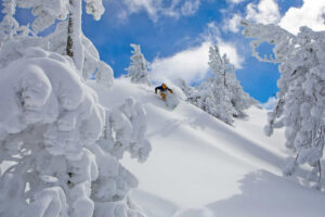
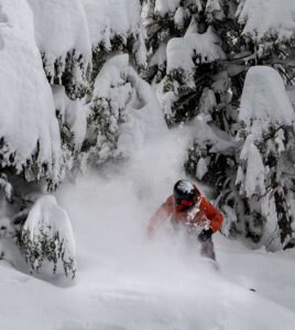
While the snowfall Thursday at Tahoe ski resorts was being measured in inches, one day later it could be measured in feet.
According to OpenSnow forecaster Bryan Allegretto, Tahoe ski resorts could be reporting 3-4 feet of new snow by Friday morning on their upper summits.
“We’re tracking 3-4 feet from this storm, which could be our biggest two-day snowfall of the season,” a message on the Sugar Bowl website stated. “After an incredible early season followed by a dry January, this system might just push us back to our season-to-date (snowfall) average.”
Sugar Bowl was among five Tahoe ski resorts that reported 8 inches of fresh snow Thursday morning (Feb. 13). Mt. Rose had a foot of new snow and Kirkwood was right behind with 11 inches.
“It’s absolutely dumping on the slopes now and there is plenty more snow in the forecast today,” a message on the Diamond Peak website stated after the resort got 6 inches from Wednesday’s storm.
The dumping that began overnight Thursday morning should be epic. Allegretto says the snowfall totals by Friday night could be around 28-37 inches at resort base levels, 39-48 inches near mid-mountain, and could be 45-55 inches up top.
The winds should be epic as well. Allegretto is predicting ridgetop winds gusting up to 70-90 mph Thursday, which will shut down some upper mountain lifts. The winds will come down Friday, but could still be gusting up to 30-50 mph over some exposed ridges.
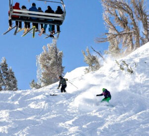
BUSY HOLIDAY SKI WEEKEND: The exorbitant amount of new snow will no doubt serve as a lightening rod in attracting skiers and snowboarders to Tahoe for the Presidents’ Day weekend.
The forecast calls for mostly sunny skies Saturday along with lighter winds. Temperature highs will be the 30s at the upper levels and low 40s near the base. Sunday and Monday should also be good weather ski days.
Traveling to Lake Tahoe anytime Thursday or Friday morning is not advisable. Anticipating a crush of traffic in the Sierra on Interstate 80 and Highway 50, officials at the state’s Department of Transportation are urging people to time their travel is to wait until it passes.
“My advice is wait until the weekend,” said John O’Connell, a spokesperson for Caltrans District 3 in the El Dorado and Tahoe area.
AVALANCHE DANGER: The Sierra Avalanche Center issued an avalanche warning for the Central Sierra Nevada early Thursday morning in response to a series of storms that have brought multiple feet of snow to mountain areas.
The avalanche warning went into effect at 5 a.m. Thursday and runs through 5 a.m. Friday, Feb. 14. The center measures the risk of danger to humans in the backcountry on a scale of one to five, with one representing a “low” risk and five presenting an “extreme” risk. Thursday’s avalanche warning was rated at a level four.
TAHOE SNOW REPORT (Feb. 13)
- Mt. Rose: 12 inches
- Kirkwood: 11 inches
- Sugar Bowl: 8 inches
- Boreal: 8 inches
- Sierra-at-Tahoe: 8 inches
- Soda Springs: 8 inches
- Tahoe Donner: 8 inches
- Northstar: 7 inches
- Diamond Peak: 6 inches
- Palisades Tahoe: 6 inches
- Heavenly: 5 inches
- Homewood: Closed for season