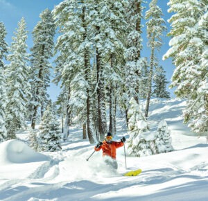
Thanks to the weather toning down its recent severity this week and more snow arriving piling up this morning, Saturday was an ideal time to hit the slopes at Lake Tahoe.

It’s been a stormy week at Tahoe ski resorts. While they’ve been hit with significant amounts of snow the past few days, the nasty weather hasn’t been great for skiers and riders. Sunday could be another OK day to be on the Tahoe slopes as well with the snow not supposed to arrive until late afternoon and continue into Monday.
Sugar Bowl reported the most snow this morning, getting 15 inches. Over the past four days the resort has received more than 4 feet (50 inches) of snow. Palisades Tahoe got 11 inches from Friday’s snow and is reporting 45 inches during the stormy period. Kirkwood isn’t far behind with 44 inches over the same time span.
CHECK OUT TAHOE SNOW REPORT BELOW
Sugar Bowl announced today it was planning to be open daily through April 13, then reopen for two weekends of operation – April 18-20 and April 25-27 (conditions permitting) before concluding the season.
“The storm door is jammed wide open. After snowing hard Wednesday through Friday, we’re catching a little lull in the storm on Saturday and Sunday, then Monday – wham,” a message on the Sugar Bowl website said.
“Another couple feet are forecasted to come our way.”
Palisades is the latest Tahoe ski resort to push past the 300-inch mark for the season and is now at 312. Sugar Bowl has the most snow among Tahoe ski resorts with 341 inches. The only other 300-inch member this season is Mt. Rose (305).
WEATHER FORECAST: According to Bryan Allegretto, OpenSnow weather forecaster, Sunday’s weather in Tahoe will be partly sunny with increasing clouds through the afternoon as the next storm approaches. He says winds will be gusty at times and likely close quite a few upper mountain lifts.
Allegretto is predicting a vigorous cold front will push through Sunday night into Monday morning with a period of heavy snow. The latest model shows steadier snow reaching the mountain between 8-10 pm Sunday and then pushing south through the Sierra overnight.
Snow showers behind the front could linger into Monday evening before drying out overnight into Tuesday morning. Allegretto predicts a weak high pressure builds in briefly Tuesday into Wednesday.
ANOTHER MIRACLE MARCH? Some years, March has been historically the most prolific snowfall month in the Lake Tahoe region. Prior to the heavy snow this week, March had already delivered several storms in its first few weeks, totaling more than a foot of fresh powder.
The latest storm system, which continues into early next week, is predicted to bring some of the heaviest snowfall totals this ski season.
“The last significant storm we had came in multiple waves. This storm is bringing heavier snowfall rates, and we’ve got some larger snowfall totals,” said Gigi Giralte, a meteorologist with the weather service’s Reno office.
The March snow is needed. Many Tahoe ski resorts are still under the 200-inch level for the season. Although the totals have been less in recent years, historically Tahoe resorts average 300 to 500 inches of snow per year.
TAHOE SNOW REPORT (March 15)
- Sugar Bowl: 15 inches
- Boreal: 13 inches
- Palisades Tahoe: 11 inches
- Soda Springs: 11 inches
- Northstar: 7 inches
- Kirkwood: 7 inches
- Diamond Peak: 6 inches
- Tahoe Donner: 6 inches
- Sierra-at-Tahoe: 5 inches
- Mt. Rose: 5 inches
- Heavenly: 5 inches
- Homewood: Closed for season