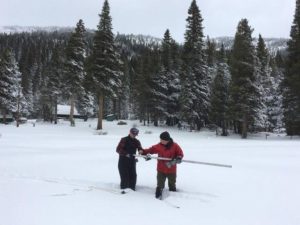
Despite a snow storm that has dumped 2-3 feet in the Lake Tahoe region over the past two days, the overall snow total is underwhelming.
The current snowpack was measured Tuesday at Phillips Station near Echo Summit near South Lake Tahoe. The state’s first official manual snowpack reading for 2017 was 53 percent of average. The survey is the 20th time in the past 30 years that snow water content at the Phillips location fell below historical averages for Jan. 1, according to a review of Department of Water Resources data. The 53 percent was the 14th lowest measurement in the last 50 years.

Note that the measurement provides only a small snapshot of the state’s snow-water conditions. Electronic sensors that monitor the entire snow water content in the Lake Tahoe area show that as of Tuesday the state’s snow water content is at 70 percent of normal.
This figure is not good news. Nearly two-thirds of California, the majority being located in the southern half of the state, remains under drought conditions, according to the U.S. Drought Monitor. Last year at this time, about 98 percent of the state was in drought mode.
According to the Western Regional Climate Center, the average temperatures in the Lake Tahoe region have trended warmer over the last several years. Warmer temperatures indicate that more precipitation falls as rain rather than snow in the Tahoe mountains, which is not ideal. The state’s water infrastructure is built around capturing and storing melting Sierra snow so that it can be portioned out for irrigation and drinking water during California’s hot summers and falls.
The average temperature at Squaw Valley, which resides at 7,200 feet, was 36 degrees between October and March during the last 10 years. The average Squaw Valley temperature over the previous 100 years was 33 degrees, the Western Regional Climate Center data show.
The low snowpack will no doubt rise over the next week. The National Weather Service has issued a winter storm warning in effect through Wednesday night in the Lake Tahoe region. The storm is expected to bring between 2-7 feet of snow to the Tahoe area. Forecasters say the Truckee area should get a respite from the storm on Thursday night and Friday. Another storm should arrive by Friday night, but it’s expected to be warmer with much higher snow levels.